



By Kawsar Mia
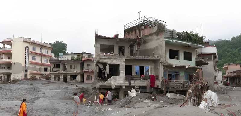
The catastrophic flood that struck the Nepal-Tibet border on 26 August should not be treated as a isolated mountain disaster. It is a warning for every downstream country whose water, food, energy and infrastructure depend on the Himalayan system. By early September, more than 1,300 people had been reported dead across Nepal and Tibet and around 5,000 remained missing. For Bangladesh, the disaster is at once a human tragedy, a scientific warning and a test of whether national planning is capable of looking beyond political borders.
What Actually Collapsed

Initial reports treated the event as a possible earthquake or a familiar glacial-lake outburst flood. Subsequent evidence pointed to something more complex. Seismic and satellite analysis found that a large mass of glacier ice and underlying rock collapsed near the Nepal-China border, fell for more than a kilometre, generated a massive debris flow and temporarily blocked the Lhende Khola before the natural dam failed. The seismic signal initially classified as an earthquake was later attributed to the collapse itself.
The event was not entirely invisible beforehand. A Nature analysis reported that satellite observations from the weeks before the disaster showed accelerating movement in the glacier-rock system near the apparent failure zone. That does not mean the catastrophe could have been predicted with certainty, but it does show why high-mountain monitoring, rapid data sharing and transboundary early warning are becoming strategic necessities rather than optional scientific projects.
Beyond the GLOF Risk
The broader lesson is that future Himalayan disasters will not fit neatly into one category. Glacier collapses, ice-rock avalanches, landslides, temporary river blockages, natural-dam failures and sudden flows of sediment and debris can combine into cascading events within hours. ICIMOD now calls for sustained, standardised and basin-representative cryosphere monitoring across the Hindu Kush Himalaya precisely because hazards in one part of the mountain system can quickly propagate into water, energy and settlement risks elsewhere.
The climatic backdrop is equally serious. ICIMOD reported in March 2026 that glacier wastage in the Hindu Kush Himalaya has roughly doubled since 2000, while glacier area fell by about 12 per cent between 1990 and 2020. These glaciers feed major Asian river systems and support the water, food, energy and livelihoods of nearly two billion people. The crisis is therefore not confined to mountain communities.
Bangladesh Sits at the End of the Basin
Bangladesh needs to read the disaster through basin geography rather than national maps. The Asian Development Bank notes that Bangladesh occupies only about 8 per cent of the total drainage area of the Ganges, Brahmaputra and Meghna river systems and sits at their downstream end. Transboundary inflows dominate the country’s surface-water system. Much of Bangladesh’s water security is therefore shaped by rainfall, snow, glaciers, river regulation and land-use decisions far beyond its borders.
A Himalayan glacier collapse will not automatically produce a disaster in Bangladesh, and the distance between a mountain hazard and a delta impact matters. But upstream shocks can alter river flow, sediment loads, erosion, reservoir operations, navigation, fisheries and agriculture. The policy implication is straightforward: Bangladesh cannot build a serious water-security strategy while treating the Himalayas as someone else’s environmental problem.
Five Changes Bangladesh Should Make
First, flood forecasting must look much farther upstream. Bangladesh already operates a national Flood Forecasting and Warning Centre, but the next generation of forecasting should incorporate shared information on glacier movement, glacial lakes, snow cover, extreme rainfall, landslides, reservoir levels and river flow across the wider basin. China, Nepal, Bhutan, India and Bangladesh need faster protocols for sharing observations that can affect downstream safety.
Second, water diplomacy must move beyond bargaining only over seasonal allocation. Water-sharing remains important, but modern river diplomacy should also cover emergency releases, reservoir operating information, sediment, glacier and landslide warnings, and communication during transboundary disasters. A warning received hours earlier can be as important to public safety as an agreement on average dry-season flow.
Third, infrastructure standards must stop assuming that the climate of the past will define the climate of the future. Bridges, embankments, power plants, economic zones and cities should be tested against changing rainfall extremes, sediment loads and cascading hazards. Major projects in river corridors need mandatory resilience assessments that examine not just historical floods but plausible future extremes.
Fourth, Bangladesh’s position on Himalayan hydropower should be science-based rather than automatically supportive or automatically hostile. Projects should face cumulative basin-level risk assessment covering earthquakes, glacier collapse, landslides, sediment, natural river flow and downstream consequences. Where risks cannot be reduced to acceptable levels, redesign, operational safeguards or suspension should remain possible. Renewable energy is valuable, but the label “renewable” does not by itself make infrastructure safe.
Fifth, rivers, haors, beels, wetlands and floodplains should be treated as protective infrastructure. Filling wetlands and constricting rivers while relying almost entirely on concrete embankments reduces the landscape’s natural capacity to store and release water. Disaster resilience depends not only on stronger structures but also on preserving the spaces through which water can move safely.
Preparing for Flood and Scarcity Together
Another misconception is that glacier loss means only more water. In the short and medium term, rapid melting, unstable slopes and extreme rainfall can increase flood and debris-flow risks. Over the longer term, shrinking ice and snow reserves can make dry-season flows more uncertain. ICIMOD’s 2026 glacier assessment warns that accelerated ice loss is already reshaping water availability and hazard patterns across the region. Bangladesh therefore has to prepare for two futures at once: too much water at some times and too little at others.
Governance Must Follow the River System
This is also a governance problem. Rivers do not recognise political borders, and glacier instability does not stop at customs posts. The natural flow of rivers, the water-holding capacity of wetlands, mountain stability and the regenerative capacity of ecosystems are not environmental side issues; they are conditions for long-term development. If an upstream project creates energy or financial benefits while shifting disproportionate risks downstream, those risks should be measured, disclosed and addressed through basin-level cooperation.
Bangladesh Needs a Himalayan Risk Centre
Bangladesh should establish a national Himalayan and transboundary river risk monitoring centre linking the Water Development Board, Flood Forecasting and Warning Centre, Water Resources Planning Organisation, Joint Rivers Commission, Meteorological Department, remote-sensing institutions, universities and research organisations. Its task should be to monitor upstream hazards, combine satellite and hydrological data, assess cascading risks, coordinate international information requests and translate technical warnings into clear public messages.
The same logic should be embedded in long-term planning. The Bangladesh Delta Plan 2100 is already designed as a long-term, climate-sensitive framework for water and land management. A dedicated cryosphere and transboundary-hazard component would connect the delta’s future more explicitly to the mountains that feed its rivers.
National Security Begins Upstream
The central lesson from Nepal is that Bangladesh’s water security does not begin at its own border. It begins in Himalayan ice, the Tibetan Plateau, the mountains of Nepal and Bhutan, and the vast upstream catchments of India. Changes there can eventually affect food, energy, agriculture, settlements, navigation, industry and livelihoods in Bangladesh. Environmental security in the Himalayas should therefore be treated as part of Bangladesh’s national-security conversation.
If Bangladesh sees the Nepal disaster only as another tragedy to be followed by relief and reconstruction, it will miss the wider warning. The task is to move from reactive disaster management to anticipatory governance: better science, regional data sharing, climate-resilient infrastructure, stronger river diplomacy and institutions able to see the entire basin rather than only the water that has already reached Bangladesh. For a downstream country, strategic foresight begins upstream.
Author: Kawsar Mia – Lecturer, Civics and Good Governance, Cosmopolitan College, Dhaka, Bangladesh.
(The opinions expressed in this article belong only to the author and do not necessarily reflect the views of World Geostrategic Insights).
Image Source: AFP