


The global trading map is on the verge of a historic redraw. Amid growing strategic competition and fragility in global supply chains, two ambitious infrastructure projects, India’s Great Nicobar Project and Thailand’s Ranong-Chumphon Landbridge, are quietly converging to form what could become a transformative Indo-Pacific maritime corridor.

Taken individually, each initiative is bold. Combined, they are potentially revolutionary, birthing what could be Indo-Pacific’s own “New Suez Canal”: a logistics, trade, and security corridor capable of challenging the traditional maritime order that has dominated for over a century.
Two Projects, One Strategic Vision
India’s Great Nicobar Project, located at the southern tip of the Andaman & Nicobar Islands, is more than just a logistics hub. With a projected investment exceeding $10 billion, it includes a deep-sea International Container Transshipment Terminal (ICTT), with an ultimate capacity of 16 million TEUs, at Galathea Bay, a new Great Nicobar International Airport (GNIA), green/gas and solar power infrastructure, township and military logistics facilities. Situated just north of the Malacca Strait, it places India at the gateway of the busiest shipping lane in the world.
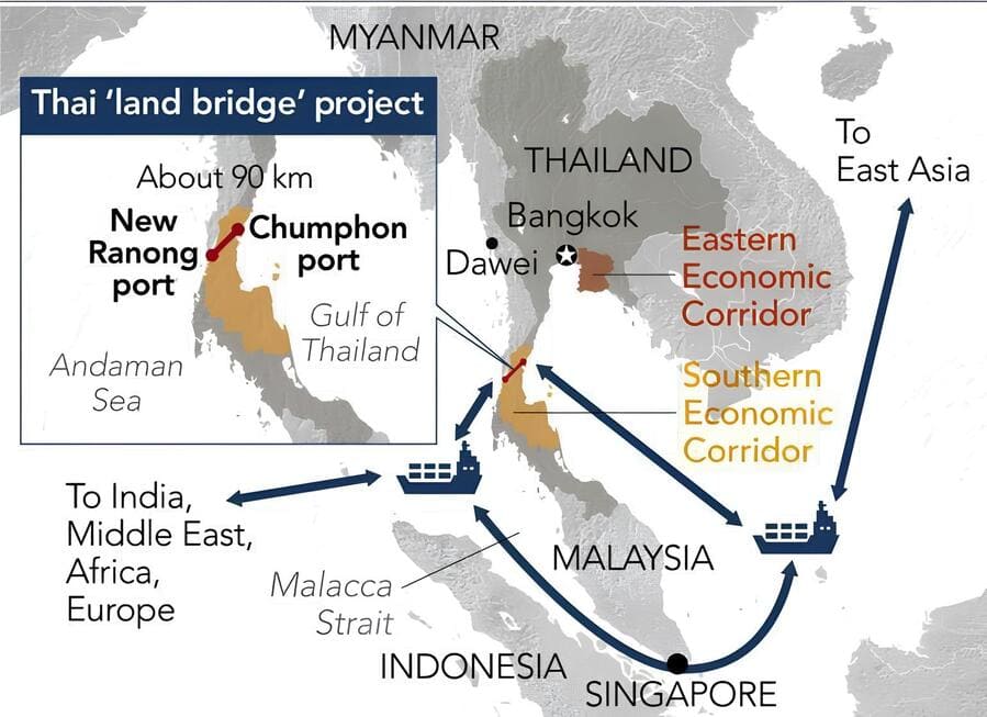
Thailand’s Landbridge Project, meanwhile, approved in principle by Thai authorities Oct 16, 2023, intended to connect Gulf of Thailand (Pacific side) with Andaman Sea (Indian Ocean side) via two deep sea ports (Laem Riow/Chumphon & Laem Ao Ang/Ranong), connected by a modern transport corridor: highway, rail, etc., via 89.35 kilometres transport corridor between Chumphon and Ranong. The network entails a six-lane motorway and both standard-gauge and meter-gauge railways. By replacing the congested and vulnerable Malacca Strait route with a short overland freight corridor, it promises to cut days off maritime shipping times and reduce fuel and insurance costs by 15%. According to a comprehensive study by the Office of Transport and Traffic Policy and Planning (OTP), Thailand, the project’s Economic Internal Rate of Return (EIRR) is a high 17.38%. It may generate up to 280,000 jobs and fuel new business opportunities in industries, including food processing, pharmaceuticals, and tourism.
On their own, these are strategic infrastructure moves. But when seen as part of a larger regional architecture, a new possibility emerges: a coordinated East-West Maritime Corridor that circumvents the chokepoint of the Malacca Strait entirely.
The Malacca Strait: Still Strategic, But No Longer Singular
The Strait of Malacca, narrow, congested, and vulnerable, has long been a critical artery for global trade. Over 90,000 vessels transit through it each year, including 40% of global trade and 80% of China’s oil imports.
But chokepoints are, by nature, risky. Disruptions, including weather, congestion, political risk, can paralyze trade. Piracy, accidents, and great power competition increasingly make the Strait a pressure point. The Suez Canal crisis in 2021, and more recently, disruptions in the Red Sea, have shown the world just how fragile our logistics arteries truly are.
In this context, India and Thailand’s vision offers a resilient, strategically distributed alternative, possibly enabling part of traffic to “hop” over land in Thailand instead of sea around Malay Peninsula.
Geoeconomic Multiplier: A Shift in Asia’s Trade Gravity
The Nicobar-Ranong axis has the potential to rebalance Asia’s trade flow. Here’s how:
A vessel from West Asia or Africa could offload at Great Nicobar’s deep-sea port. Cargo is transshipped to Thailand’s Ranong port via coastal feeder vessels or direct lanes. Goods then cross the Landbridge to Chumphon, from where they’re shipped onward to the Pacific: Japan, Korea, China, or the U.S. West Coast.
This not only reduces transit time by 4-6 days, but also bypasses geopolitical hotspots, high insurance zones, and congested maritime routes. For shippers, time is money. For governments, control is leverage. The combined potential of the two projects includes lower trade costs, faster shipping, new SEZs, logistics zones, industrial chains spread across India, Andaman/Nicobar, Thailand, plus spillovers into Myanmar, Indonesia, etc. Also, new supply chain routes, better access for Indian exports to Southeast Asia and beyond, perhaps even serving parts of East Asia more efficiently.
Thus, this corridor integrates South Asia and Southeast Asia in a physical, geoeconomic architecture, not just diplomatic rhetoric. It’s the materialization of India’s “Act East” and “Look West” in bricks and mortar.
Strategic Upside: Beyond Trade
It would be a mistake to view these projects through purely commercial lenses. Their strategic consequences are profound. For India, Great Nicobar strengthens its eastern maritime frontier, allowing for rapid naval deployment across the Indo-Pacific. It supports India’s vision of being a “net security provider” in the region, counterbalancing Chinese encroachments in the Indian Ocean. India can project naval, air force, and logistical presence from Great Nicobar, Thailand’s Landbridge can be defended and leveraged with allies. This could alter regional power balances, especially vis à vis China, which has been increasing presence in the Indian Ocean and Southeast Asia.
For Thailand, the Landbridge reduces its dependency on the Malacca route (controlled largely via Singapore) and elevates its geopolitical weight within ASEAN. Thailand (and ASEAN) gains an elevated role as a logistics and trade hub between Indian & Pacific Oceans. Combined, they could shift some of the weight away from traditional hubs (Singapore, Sri Lanka, etc.). Also, the joint infrastructure could draw investment, technology, security partnerships. Together, they offer regional partners, Japan, Australia, the EU, and even the U.S., a non-China-centric trade corridor. One that is open, democratic, and rules-based.
The strategic calculus is clear: whoever controls the lanes of logistics, controls the lanes of leverage.
Will Global Powers Play Along?
Washington is likely to back the corridor, especially if it aligns with its Indo-Pacific Strategy and offers alternatives to China’s Belt & Road Initiative (BRI). Infrastructure financing may flow through the Blue Dot Network, defense partnerships may strengthen to ensure security along the corridor, and technology partnerships in port digitization may further deepen mutual benefits and cooperations.
Beijing may view this as a subtle containment move, aimed at disrupting its Maritime Silk Road dominance. However, if the corridor remains open to Chinese trade (which it likely will), economic pragmatism may prevail. Still, don’t rule out China doubling down on Myanmar ports (e.g., Kyauk Phyu) or increasing influence in Sri Lanka as a counterweight.
As trade-dependent nations, both Tokyo and Seoul will welcome the corridor. Japan is already one of the largest investors in India’s port infrastructure and could play a key role in developing both Nicobar and the Landbridge. South Korea, too, sees this as a de-risking opportunity for its exports.
Europe, especially Germany and France, seek diversification after Suez-related shocks. Gulf nations, like Saudi Arabia and UAE, eager to become east-west logistics hubs, may invest directly in port development, energy terminals, and logistics parks along the corridor.
Risks on the Horizon
But grand visions are often tripped by inconvenient realities:
– Environmental Resistance: The Great Nicobar Project faces opposition over alleged threats to biodiversity and indigenous rights. Thailand’s Landbridge has drawn protests from local fishing communities and environmental groups.
– Funding Gaps: Thailand’s project may cost $28 billion; India’s, upwards of $11 billion. These are massive, long-term commitments requiring public-private partnerships and stable political backing.
– Implementation Lags: Coordination between two sovereign nations, each with its own bureaucracy, regulatory systems, and strategic outlook, can delay integration.
– Geopolitical Pushback: China may view this as encroachment and respond with “counter-corridors” through Myanmar, Sri Lanka, or via militarization of key sea lanes.
But if these challenges are met with resolve, transparency, and regional buy-in, the Nicobar-Ranong axis could stand not just as infrastructure, but as infrastructure diplomacy, a new tool of statecraft.
Conclusion: Indo-Pacific Prosperity Corridor from Vision to Velocity
The vision of a new Suez-style axis in the Indo-Pacific is no longer theoretical. It is taking shape in concrete, steel, and strategic will. The Great Nicobar-Ranong Landbridge Corridor is not just about trade, it’s about shifting the very center of gravity of Asia’s connectivity.
In a world desperate for supply chain resilience, geopolitical balance, and environmental sustainability, this corridor could be the 21st century’s answer to 20th century bottlenecks.
It remains to be seen whether India and Thailand can turn their potential into power. But if they succeed, the world may one day speak of the Nicobar-Ranong Corridor in the same breath as Panama or Suez, not just as a passage, but as a pivot.
Author: Yashwant Singh – Assistant Professor at the Department of Sociology at GITAM (Deemed to be) University, Bengaluru Campus, Bengaluru, Karnataka, India. He has an M.Phil in Sociology from the University of Delhi and Ph.D in Sociology from University of Hyderabad, India. His research interests include urban sociology and sociology of development.
(The views expressed in this article belong only to the author and do not necessarily reflect the views of World Geostrategic Insights).
Image: A 3D modelling of the port to be built on the Great Nicobar island. Source: India Shipping Ministry/BBC